Since the weather has warmed up, we decided to take a ferry ride to Peaks Island, the most populated island in Casco Bay. The year round population is less than 900, while the summer population is over 6,000 residents. Peaks Island is part of the city of Portland. The large windjammer sailing boats you can see in the picture below take visitors on whale watching cruises during the summer.
We boarded the Peaks Island ferry for a 15 minute trip across Casco Bay. This ferry is an actual working ferry, carrying about a dozen vehicles to Peaks Island. As you can see, most of the vehicles on our trip were commercial vehicles delivering goods to Peaks Island businesses or performing work for island homeowners.
There were a few seals playing near the Portland waterfront as our ferry left the dock. The seal below was playing hide-n-seek, as you can see him diving beneath the water as he was coming close to a dock..
The ferry ride across Casco Bay was very picturesque. Our ferry passed Fort Gorges which we had viewed from the mainland during our bike ride a week ago. Notice how high the water is. Because it was high tide, we got the impression that the fort was flooded.
We passed very close to several lobster buoys enroute to Peaks Island. Every lobsterman is issued a color scheme and number by the state to brand into their buoys. The registration number is visible on the buoy below. Also, the water is clear enough that you can see about 2 feet of rope going down to the trap.
We were able to get photos showing artistic reflections of some buoys in the calm water.
Below is a view of the pier just prior to docking at Peaks Island, inviting visitors up the hill to begin exploring the island. The vehicles lined up along the left curb on Welch Street are in line to get on the ferry for the return trip to Portland.
As passengers lined up, the vehicles were first to leave the ferry. The ramp was raised by a crew member who used a remote control after a few vehicles have left the ferry. The ferry then had less weight and therefore rose in the water. If the ramp is not raised, then the incline would be extremely steep for the rest of the debarking vehicles.
We decided to walk around the island rather than take our bikes since the island is only 3 miles long and 1 mile across.The route we took was past many gorgeous vistas.
A lone sailboat cruising between Peaks and another island as the waves gently crashed along the rocky shoreline.
Just like the mainland coast, Peaks Island has a very rocky shore..
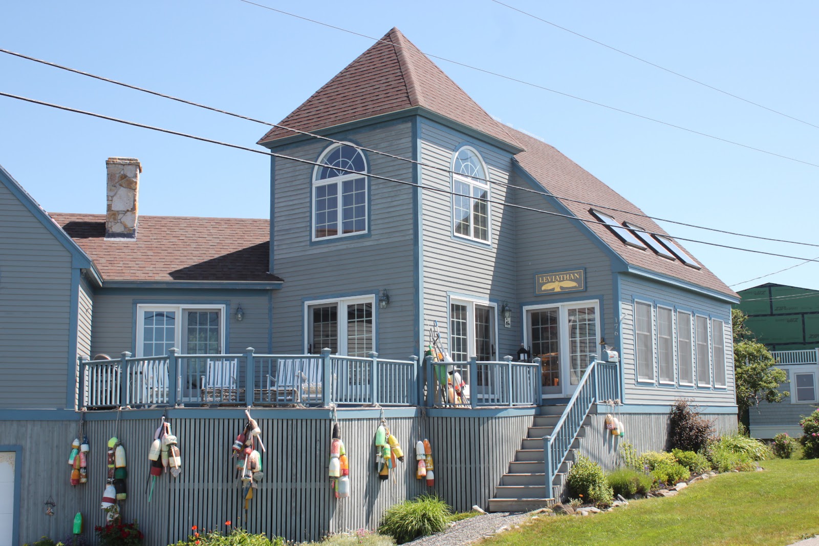
Here is one of the shore homes we passed on our walk. Many were much larger and most had great views. Some houses are decorated with lobster buoys.
One thing that was noticeable was that many of the homes have been given names by their families. Here is "Leviathan". Other names seen included "Our Paradise" and "Nokomis", which we in Florida know as a a small community south of Sarasota but which is also an Indian term for grandmother in Longfellow's poem Hiawatha.
We don't know if residents or visitors have constructed stone art that we periodically saw along the coast. In talking to one of the residents, she said that no one seems to disturb these towers along the shore line. The rocks are very flat and stack easily, but we did not leave our personal artistic mark on the island.
Weather forecasting can sometimes be done in an unusual manner. Here is the Peaks Island weather rock, with an island native telling it like it is in plain terms.
Like other small communities, Peaks Island has its own post office. The window flower boxes add color to the appearance of the building. Does your local post office look this nice?
We concluded our four mile walk around Peaks with a nice lunch at The Inn on Peaks. Paul is sitting on the porch overlooking the ferry dock. Notice the golf carts lined up on the far side of the street. These are in place to be rented to tourists coming off the next ferry. The food was good and reasonably priced and the view was priceless. Does it get any better than this?
All good things must come to an end, so as our ferry approached Peaks Island, it was time to get in line to board.
Another option to get to Peaks Island is to use a water taxi. We passed this taxi on our return trip to Portland. According the internet, the private water taxi trip costs $100 each way, while our ferry tickets were under $8 round trip. A no-brainer choice!
We are really beginning to like the Maine summer weather. If all our days off were this perfect, we might think we were in heaven.
We had heard many good things about the coastal area between Boothbay Harbor and Portland. Being hikers, we thought it best to take a hike before playing tourist so we headed to Reid State Park near Georgetown, Maine. The salt air aroma filled our nostrils once we started walking towards the trailhead at Todd's Point. There was a considerable ocean breeze, so we both put on long-sleeved shirts for our walk. We explored the rocky coast before heading along the beach towards Griffith Head.
Maine has some sparkly rocks called mica. What sometimes appears to be bits of broken glass is actually bits of mica. We found this large mica rock on the beach at Reid State Park. It shone brilliantly in the sunlight, but we could only capture a portion of the shine in the photo.
There was a lot of driftwood back near the top of the sand dunes, probably pushed back by a strong storm and thundering waves - who knows how many years or even decades ago.
The bushes above the driftwood with the pretty pink flowers are called Virginia Rose. These bushes grow wild everywhere along the beach, giving some early summer color to the beach vegetation.
During our walk down the beach, we found an example of human creativity. Remember the movie Castaway? Castaway starred Tom Hanks and was about a FedEx employee who was the sole survivor of a plan crash, stranded on an uninhabited island for several years before being rescued. During a first attempt to make fire, he receives a deep wound to his hand and in his anger threw several objects including a Wilson Sporting Goods volleyball he found in one of the packages on the downed plane. A short time later he drew a face in the bloody hand print on the ball and named it Wilson and began talking to it.
This Wilson is not a round volleyball but is certainly a tribute to the Castaway version. Notice the Rolling Stones lips and Mr. Potato Head nose. Some budding artist came to the beach prepared to finish the tribute statue. The pirate head scarf adds a nice touch to the shipwreck theme.
From the Castaway movie. Do you notice a resemblance?
Down the beach, we noticed an area that was roped off. The fence around the area was to protect the nests of either Terns or Plovers, two endangered species of shore birds in Maine.
The tide was going out, so we walked along the wet sand, but it was still soft and made for difficult walking. This photo shows the tide going out as well as small tide pools.
Another view of the tide rushing out from a small bridge near a cove.
Further along the woodsy portion of our hike we found some kudzu. Not the Southern version of vines that envelop trees, but a Maine summer wild flower.
After completing our 4 mile walk, it was time to drive to Five Islands for some fresh Maine seafood. A co-worker had told us about Five Islands Lobster Company, where you order your food at a window and then go eat at one of their picnic tables overlooking the harbor. We were not disappointed with our lunch or the typical Maine setting.
A photo op from the back deck. Notice all the lobster traps waiting to be put back out to sea.
One of the larger lobster boats along the dock at Five Island Lobster Company.
You can see just how far out the tide has gone dropping the water level way down. Look at how steep the gangway is down to the floating dock by this house.
How can you top eating fresh seafood with postcard views like these? The sun was shining brightly and the cool breeze was blowing in off the ocean.
Our journey to this part of coastal Maine would not be complete without a drive out to Bailey Island, which is just south of Bath. We found more postcard views as we wandered down the island, 5 miles of breathtaking ocean scenes.
What a fabulous day in the near summer-like weather. Views like the one above are one of the reasons we chose Maine as our summer destination for 2013.
After two consecutive days of rain, the sun came out on our second day off this week. It was time to explore Portland by bike. We noticed when we walked the Back Cove path last week that it connected to the Eastern Promenade, a biking and walking trail that runs along the eastern shore of the city and ends at the Portland waterfront. Since there was a large - and free - parking lot at Back Cove, we began our journey there, peddling partially around Back Cove, then picked up the Eastern Promenade bike trail. The trail is part of the East Coast Greenway, a trail that will one day link Calais, Maine, with Key West, Florida.
First stop was Eastern Park, which has a small beach. How would you compare this beach to the beaches in Florida, the Jersey Shore, or elsewhere? There is a small ferry in the upper left of the photo. While the sun was shining when we began our ride, it soon became an overcast day.
Here is a closer look at the ferry just after a truck had driven onto the ferry. The truck gives you some perspective of just how small this ferry is. There are over 100 islands off the southern Maine coast east of Portland, although only seven can be reached by ferry service. We don't know which island this ferry visited, as no signage was displayed near the boat ramp.
Out in the harbor, we noticed a large fort built on an island. Fort Gorges was built by the U.S. Army Corps of Engineers during the civil war on Hog Island Ledge in Casco Bay at the entrance to Portland Harbor. It is similar in size and construction to Fort Sumter except that it is built of granite instead of brick. It was acquired by the city of Portland in 1960 and placed on the National Register of Historic Places. It is now open to the public as a park, but is accessible only by private boat, so we won't have a chance to get out there.
Paul taking a break and enjoying the harbor scenery.
On our return from Portland, we traveled the rest of the Back Cove trail, for a total ride of 12 miles. Not bad for our first trip - but will we be stiff tomorrow?
Sometime during the summer, we hope to load our bikes on a ferry to travel to at least one of the islands off the Portland coast and explore the island by bike.
Last year we rented bikes in Wyoming to try bike riding as an additional form of fitness. In the fall we purchased "comfort bikes" and rode them a few times in both Gainesville and Sarasota. We brought our bikes along to Maine so we could explore some of the unique trails in the Portland area. Today was the day we were going to use them for exploring. Unfortunately, when we uncovered the bikes we found one of the tires was flat. After filling it with air, you could hear the air escaping, so repairs were needed.
The day wasn't a total loss, though. There wis a nice 3.5 mile loop around Back Cove, a large sheltered body of water off Casco Bay in Portland that could either be biked or walked. It was also near the bike shop where the tire tube was being replaced. Part of the route took us past the B & M Baked Beans factory. As we walked, we could smell the aroma of freshly baked beans - difficult to resist, since it was hours since we had breakfast. An eight-lane interstate highway kept us from seeing if they had a factory tour with samples.
We did walk past some stately homes overlooking the cove with a fabulous view of the Portland skyline.
Next on our agenda was a stop at the Allagash Brewing Company for their tour and a tasting. Allagash brews Belgian style beer as opposed to German style or British style beers. Allagash Brewing Co. was founded in 1995 by Rob Tod after he recognized the need for craft beers in New England.
The bar in the tasting room was made from old barn timbers and looked very antique-like yet modern. Our samples were served in miniature glass brandy snifters set in a rack. Our tour guide said that the use of this unusual glassware was to take advantage of the aroma as a component of the beer tasting experience.
There was a unique candelabra hanging over the beer taps. Yes, the lights are inside 22 ounce beer bottles arranged in an artistic design.
The factory has recently been expanded and was very clean and modern looking. One of the Allagash motivational sayings is shown painted on a large stainless steel tank in the new brewing room. This saying, "Passion: Loving beer and doing what we love", gives you an idea of the motivation for craft brewers.
One of the Allagash beers, Curieux, is aged in oak barrels that where once used for storing Jim Beam bourbon. This was one of the beers we tasted and yes, you could certainly taste a hint of the bourbon just after swallowing the beer. Paul is shown in the chilled storage room for this and some other more experimental brews. You can see the beer types and date of kegging on the barrel in white chalk.
Allagash used the moose in a cartoon ad to draw attention to its flagship beer, Allagash White. We also sampled the White. It tasted like a summer ale with hints of a fruity after-taste. In case the photo below is difficult to read it says "I know I stashed the Allagash in here somewhere."
All in all, a day that started out as a bit of a disappointment, turned into another great day of sightseeing. We will save the first bike ride for another time.
We headed to the Lake Region of Maine to explore this area of lush forests and many large fresh water lakes. We decided to explore Lake Sebago State Park, which is about 45 minutes NW of Portland. Sebago Lake is Maine's deepest, 316 feet at its deepest point, and second largest lake, about 45 square miles with about 105 miles of shoreline.
When we pulled into the parking lot, we were the only car in the entire parking lot of hundreds of spaces! It was a mild day for Maine, so where were the people to enjoy this beautiful beach?
Once we began walking along the beach, we did find another car at a different parking area with a mother and three pre-school age children who were actually in the cold water. The air temperature was around 60 with a breeze blowing towards the lake shore. I wonder how cold the water was? Probably in the upper 50's - way too cold for us to swim.
Paul is shown below along the lake shore wearing a vest because of the cool breezes. This photo only shows a very small part of the lake. The sand was a darker brown than what is found at our campground and made the water appear to be iced tea in color.
Along the lake shore, we found some live evergreens with their roots exposed from the movement of the lake water washing away the sand around the roots. It was surprising that these trees are still thriving with their bare roots exposed to the elements.
Once we headed back away from the beach area, our 4-mile hike was through heavily wooded terrain. A portion of the hike was along the Songo River which provides the passage of boating traffic from Long Lake and Brandy Pond through the Songo Locks to Sebago Lake. There is a four foot difference in the water levels of Long Lake and Sebago Lake, necessitating the need for the locks.
The forest was dominated by many types of trees, several of which we haven't seen so far including beech and quaking aspen trees. When the sunlight was able to get through the foliage, there were often clumps of small pine trees two to three feet high and occasional areas of ferns. We encountered no wild flowers during our hike; perhaps because there just isn't enough sunlight for flowers to grow. Notice how close together these small pines are. Eventually, the stronger of the small trees will survive because there is only so much sunlight available for the trees to grow.
We did find several downed tree trunks covered with moss. I wonder how long this tree has been lying on the ground to gather this much moss?
We also found several trees covered with an algae of some sort that looked like mushrooms.
The only wildlife we encountered were a Canada goose, squirrel, chipmunk, and this pretty scarlet tanager. The Canada goose was too far out in the lake to get a good photo but its honking sound was unmistakable. The squirrel was too high up in the tree but again, we heard its unmistakable shrill sounds first before spotting it. The chipmunk barely poked his head out of his little den before disappearing for good. We were lucky to get a photo of the beautiful scarlet tanager shown below because these birds normally stay way up in the trees.
After our picnic lunch we drove about 10 minutes further north to Naples, Maine, to enjoy a cold beer at Brays Brew Pub and Eatery.
It was a great day to explore the Lakes Region, since the temperatures were back to normal June levels. This past weekend, we had two days with temperatures in the low 90's. Some of the locals have told us that the summer in Maine only lasts about 20 days. Time will tell just how true that old wives tale might be.


